Showing posts with label Google Earth. Show all posts

Google Earth Tour Builder

Donal Trung 12:13 PM Add Comment
Google has a new experimental service that lets you build Google Earth tours from your browser. It's called Tour Builder and it requires the Google Earth Plugin (you also get the plugin when you install Google Earth).

"Tour Builder is a new way to show people the places you've visited and the experiences you had along the way using Google Earth. It lets you pick the locations right on the map, add in photos, text, and video, and then share your creation. We originally created Tour Builder to give veterans a way to record all the places that military service has taken them, and preserve their stories and memories as a legacy for their families. But we also thought it could be a useful tool for anyone with a story to tell, so we made it available to everyone," explains Google.


Before creating a tour, you can check the gallery:


Tour Builder lets you add images and videos, import KML files, enable or disable some layers, add historical imagery. By default, tours are private, but you can share them with other people.


{ Thanks, Florian K. }

Google Earth optimized for Android-powered tablets

Donal Trung 10:02 AM Add Comment
Cross-posted from the Official Google Blog

When we launched Google Earth in 2005, most of us were still using flip phones. At the time, the thought of being able to cart around 197 million square miles of Earth in your pocket was still a distant dream. Last year, that dream came to fruition for Android users when we released Google Earth for Android. With the recent release of tablets based on Android 3.0, we wanted to take full advantage of the large screens and powerful processors that this exciting new breed of tablets had to offer.

Today’s update to Google Earth for Android makes Earth look better than ever on your tablet. We’ve added support for fully textured 3D buildings, so your tour through the streets of Manhattan will look more realistic than ever. There’s also a new action bar up top, enabling easier access to search, the option to “fly to your location” and layers such as Places, Panoramio photos, Wikipedia and 3D buildings.

Moving from a mobile phone to a tablet was like going from a regular movie theatre to IMAX. We took advantage of the larger screen size, including features like content pop-ups appearing within Earth view, so you can see more information without switching back and forth between pages.

One of my favorite buildings to fly around in Google Earth has always been the Colosseum in Rome, Italy:


With the larger tablet screen, I can fly around the 3D Colosseum while also browsing user photos from Panoramio. The photos pop up within the imagery so I can interact with them without losing sight of the Colosseum and its surroundings. Also, by clicking on the layer button on the action bar, I can choose which layers I want to browse.

This version is available for devices with Android 2.1 and above. The new tablet design is available for devices with Android 3.0 (Honeycomb) and above. Please visit the Google Earth help center for more information.

To download or update Google Earth, head to m.google.com/earth in your device’s browser or visit Android Market. Enjoy a whole new world of Google Earth for tablets!

Google Earth 6: Better Street View and 3D Trees

Google Earth 6: Better Street View and 3D Trees

Donal Trung 10:38 AM Add Comment
Google Earth 6 doesn't have too many new features. You can now use Street View just like in Google Maps by dragging the pegman icon. "To view street-level imagery for a specific location, zoom into an area at an altitude of approximately 500km. You will see a pegman icon appear at the top right below the navigation controls. Click and drag the icon across the 3D viewer. A blue border will appear around roads that have street-level imagery available," explains Google.

Another new feature is the "3D Trees" layer that can be enabled from the "3D Buildings" section. Google Earth includes 3D models for city parks (San Francisco, Chicago, Tokio, Athens) and remote forests (Amazon Forest).

Historical imagery is now more accessible: just click on the date of the oldest imagery in the status bar and you'll be able to see all the historical images that are available for the same location.

Google Earth 6 also adds ground-level navigation that lets you explore 3D buildings and 3D trees, 3D measurements for heights and widths of buildings and a much better Tour Recorder that improves motion fidelity.

Google Earth Includes a Web Browser

Donal Trung 12:47 AM Add Comment
Google Earth 5.2 no longer uses the operating system's web browser when you click on links. Google Earth comes with a WebKit-based browser, so you'll never have to leave the application to open a Wikipedia page or the website of a local business.

"Sometimes when you want more information, you may want to click through to a link to see the full Google Places page for a business, or learn more about a photographer whose photo you really enjoy. In the past, this has required opening a link in an external browser to see the full page. For Google Earth 5.2, we've added an embedded browser that lets you browse the full web. Click on a link, and the browser pane slides across the screen. When you want to return to the Earth view, just click the Back button," explains Google.


Apparently, Google Earth uses the Qt port of WebKit (QtWebKit) and it doesn't include the V8 Javascript engine from Google Chrome. I tried to run the V8 benchmark suite in Google Earth and the result was very poor: about 10 times lower than the latest Chromium build.

As in the previous versions, Google Earth for Windows and Mac also includes a plug-in that lets you embed a Google Earth view in any web page. Google Maps is the most popular service that lets you use Google Earth in your browser. Now you can browse the Web in Google Earth and use Google Earth in a Web browser.

If you don't like the embedded browser, you can disable it by going to Tools > Options > General and checking "Show web results in external browser".

Google Earth Tab in Google Maps

Donal Trung 12:55 PM Add Comment
Google Maps replaced the terrain tab with a tab for Google Earth. When you click on the Earth tab, Google asks you to install a plug-in for Windows or Mac. If you have a recent version of Google Earth, you already have the plug-in.

"Five years ago, shortly after Google's acquisition of Keyhole, we introduced the first integration of Keyhole technology into Google Maps -- Satellite view. Suddenly, you could see what places actually looked like from the air, and easily switch between this view and the map view. Mapping has never been the same. A few months later, the desktop Google Earth application was released, and now we have over 600 million downloads. Today we are proud to announce the next major step in the marriage between Google Earth and Google Maps -- Earth view," says Peter Birch, from Google.

Even though the new view makes it easier to use Google Earth, since you no longer have to open a new application, I think it's a bad idea to add it to Google Maps. Google Earth plug-in uses a lot of resources, it slows down your browser and it continues to run in the background even if you switch to the Map tab. What's more, if you open Google Maps in another window and switch to the Earth tab, a new instance of the Google Earth plug-in will load.


{ Thanks, Andrew. }

Offline Installer for Google Earth

Donal Trung 12:28 PM Add Comment
Downloading Google Earth is more complicated than it should be. At least if you want to download only Google Earth and save the installer for a future use. By default, Google downloads a small setup file that installs Google Earth, Google Chrome and Google Updater. Even if you disable the option "Include Google Chrome, a fast new browser for Windows and Mac", you'll still download a Web installer.

Here's how to download the standalone installer for Google Earth:

1. Go to Google Earth's homepage and click on "Download Google Earth".

2. At the bottom of the page, there's a small message: "Customize your installation with advanced setup." Click on "advanced setup".


3. Disable this option: "Allow Google Earth to automatically install recommended updates."


4. Click on "Agree and download" and you'll get the offline installer. The direct download link for the Windows version is: http://dl.google.com/earth/client/advanced/current/GoogleEarthWin.exe.

The advanced setup page offers two other interesting options: installing Google Earth for all user accounts and the full setup for Google Earth 5.0.

Google Chrome should add a similar page that lets you download the standalone installer and a version that installs the software for all user accounts. This page still offers the standalone setup, but it's an old version. Right now, Google Pack is the only option to install Chrome for multiple user accounts.

{ Thanks, Brian. }

Google Latitude, now with Location History & Alerts

Donal Trung 4:15 PM Add Comment
Since the launch of Google Latitude earlier this year, we've been getting a lot of feature requests. One of the most popular ideas was for Latitude to keep track of location history, allowing you (but not your friends) to see where you've been at any point in time. Another popular idea was to notify you when you're near your Latitude friends so you can easily meet up or grab lunch. Today, we're happy to introduce both Google Location History and Google Location Alerts (beta) to let you do even more with Latitude.

Google Location History
Whether you're taking a road trip across the country, backpacking across Europe, or just going out for a night on the town, it's fascinating to look back at where you went, and for how long you stayed. Enable Google Location History to store, view, and manage your past Latitude locations. You can visualize your history on Google Maps and Earth or play back a recent trip in order. Of course, you can always delete selected history or your entire location history at any time. While working on Location History, I found myself going back in time to discover things that would have otherwise been impossible. For example, I stopped at an awesome BBQ place on my way back from Lake Tahoe this summer, but I couldn't remember the name when my friend was asking about it a few months later. I pulled up my location history for that weekend, found where I was stationary on the drive home, and the restaurant name showed up in Google Maps: Drooling Dog Bar BQ. Check it out below:


Google Location Alerts (beta)
People also want to know when their friends were nearby, but it's not always convenient to keep checking Latitude to see if a friend has recently shown up near you. After working on this for a while, we realized it wasn't as straightforward as sending a notification every time Latitude friends were near each other. Imagine that you're Latitude friends with your roommate or co-workers. It would get pretty annoying to get a text message every single time you walked in the door at home or pulled into work. To avoid this, we decided to make Location Alerts smarter by requiring that you also enable Location History. Using your past location history, Location Alerts can recognize your regular, routine locations and not create alerts when you're at places like home or work. Alerts will only be sent to you and any nearby friends when you're either at an unusual place or at a routine place at an unusual time. Keep in mind that it may take up to a week to learn your "unusual" locations and start sending alerts.

To enable these features, go to google.com/latitude/apps. You must first be an existing Google Latitude user; if you're not already, sign up here. You must explicitly enable each feature, and of course, you can disable it at any time. Learn more in the Help Center about Location Alerts and Location History, suggest and vote on ideas in the Mobile Product Ideas page, or report problems in the Mobile Help Forum.Chris Lambert, Software Engineer, Google Mobile

Upload photos to Panoramio straight from your iPhone!

Donal Trung 3:33 PM Add Comment
Panoramio is a community of people who enjoy sharing photos of places with the rest of the world. These photos are surfaced in Google Earth and Google Maps as photo layers, where millions of users can see them.

Panoramio has just launched an application that makes it easy to upload photos to Panoramio straight from your iPhone. Read about it on the Panoramio Blog. Also, we're working hard on the Android version, so keep an eye out for it!


Posted by Fernando Delgado, Product Manager, Panoramio Team

Google Earth 5.1 Is Faster

Donal Trung 9:52 AM Add Comment
Google's 3D Earth browser has been updated and the latest build, 5.1.3506.3999, loads faster and it's snappier.

"We've made a lot of adjustments under the hood, like improving memory utilization so we can show more buildings, layers, and user content. We improved our shaders (that's graphics-speak for small programs that run inside your graphics processor) to make the atmosphere draw faster. We also worked to reduce stuttering (known as frame drops) to provide an even smoother experience as you fly around the globe. When we draw imagery, we now use compression technology to use less memory and graphics resources. We know that waiting for a program to start-up can be really frustrating, so we improved our start-up time by 25%," mentions Google LatLong blog.


While the performance improvement is noticeable, Google Earth continues to use a lot of resources. In a small empirical test, I compared the latest release with an earlier version and the results are even better than Google's claims:

Google Earth version Start-up time Memory usage when searching for "Paris"
Google Earth 5.0.11337.1968 11.5 seconds 183 MB
Google Earth 5.0.11733.9347 10.4 seconds 164 MB
Google Earth 5.1.3506.3999 6.9 seconds 145 MB

Update: If you want to download Google Earth without installing Google Updater, here's the direct download link for Windows. This build includes the plug-in for IE/Firefox/Chrome that lets you use Google Earth inside a browser. That means you'll end up with three different Google Earth versions when you upgrade: the old version, which for some reason is not removed, the new version of Google Earth and the plug-in, which wastes 33 MB by including separate copies of the files used by Google Earth.

Google Earth now available for the iPhone

Donal Trung 11:31 PM Add Comment
(cross posted with the Google LatLong Blog)

The world just got a little bit smaller. Google Earth is now available for the iPhone and iPod touch, allowing you to fly to the far reaches of the world from the palm of your hand. Since we launched Google Earth for the desktop in 2005, we've had over 400 million unique downloads, and people from around the world have used it to view their house, research travel destinations, learn how to make the world a better place, find local businesses, and view geo-located photos. Now, with a free download from the iTunes App Store, you can fly through the same 3D immersive world of Google Earth you've come to love, without having to fire up your desktop computer.


Check out this video tour to see Google Earth for the iPhone in action:


Not only is having Google Earth on your iPhone convenient, but the touch interface is a very natural way to interact with the Earth. Just swipe your finger across the screen and you fly to the other side of the globe; tilt your phone and your view tilts as well. You can pinch to zoom in or out, or just double tap with one finger to zoom in and two fingers to zoom out. We also integrated the My Location feature, so with a touch of a button, you can fly to where you are in the real world on your phone. In addition, we have over eight million Panoramio photos, which are geo-located photos of places, and you can view any and all of them from your iPhone. Besides being beautiful, high-quality pictures, they're specifically of places, so you don't have to see some guy's family on vacation in Thailand--you can see the beaches, the temples, all the things that give you a real sense of the place. Here is a nice shot of the Grand Palace that I found on my virtual tour of Bangkok.


All versions of Earth include search, and the iPhone version is no exception. You have access to the same great local search that you get with Google Maps, so you can search for places, businesses, and landmarks. With Google Earth you get to the full detail page for businesses, so you can get reviews, photos, user content, business hours, and other useful information. We also added a "search near me" feature, so with one touch you can find businesses near your location, without having to navigate there first or type in the name of the city. Looking for a good cafe when you're in Trento, Italy? It's a snap:


To get Google Earth on your iPhone, visit the App Store in iTunes or your iPhone, and search for "Google Earth."

Google Earth Reveals Iran's Nuclear Sites

Google Earth Reveals Iran's Nuclear Sites

Donal Trung 3:35 PM Add Comment

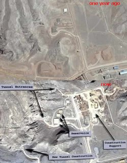
New satellite imagery indicate Iran has expanded its uranium conversion site at Isfahan and reinforced its Natanz underground uranium enrichment plant against possible military strikes.

Iran last week announced it had enriched uranium for use in fuelling power stations for the first time, stoking a diplomatic crisis over Western suspicions of a covert Iranian atomic bomb project. Iran says it seeks only nuclear energy for its economy.

Isfahan is the place where uranium is first processed and where a storage facility is being built. You can compare how it looked a year ago and how it looks now using Google Earth. You just need to import a KMZ file.

More: Ogle Earth
Google Acquires SketchUp, 3D Sketching Software

Google Acquires SketchUp, 3D Sketching Software

Donal Trung 1:23 PM Add Comment
Google acquired @Last Software, the creator of SketchUp, a powerful tool for creating, viewing, and modifying 3D models quickly and easily. SketchUp was developed to combine the elegance and spontaneity of pencil sketching with the speed and flexibility of today's digital media.

Although Sketchup is a commercial software (it costs $495), you can try it for 8 hours (31.2 MB, available for Windows and MacOS X).

One reason for which Google acquired this company is that SketchUp has a very nice plug-in for Google Earth. You can create virtual models for buildings, parks or streets.